Select Item below to DOWNLOAD - Once item is selected, right click and choose 'save as'
e1ad09dc-6656-405e-82b2-977b46f448ba
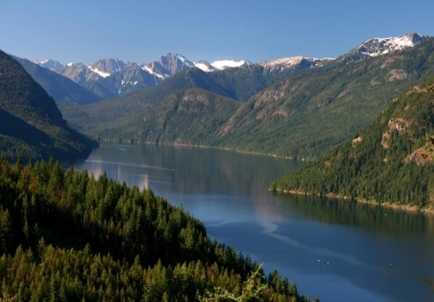
Pacific Northwest Trail - North Cascades National Park / Ross Lake National Recreation Area Segment North Cascades National Park / Ross Lake National Recreation Area
Glacier-covered peaks rise above the blue waters of Ross Lake.
A part of a continuous 1,200-mile trail route that links the Continental Divide National Scenic Trail (NST) and Pacific Crest NST with the Pacific Ocean
U.S. National Park Service
This digital asset is in the public domain. When using this asset for any purpose, including online, credit: 'Courtesy U.S. National Parks'
Andy Porter/NPS
Public domain
Image
National Trails System, Code: NTS
North Cascades National Park, Code: NOCA
North Cascades National Park, Code: NOCA
From east to west this trail leaves the Pasayten Wilderness Area after over 100 miles of wilderness hiking and crosses the Ross Lake NRA boundary on the Devils Dome Loop Trail. It then uses portions of the East Bank, Ruby-Ross, Big Beaver
North Cascades National Park, Washington
Latitude: 48.8278884887695, Longitude: -121.35050201416
North Cascades National Park, Washington
Latitude: 48.8278884887695, Longitude: -121.35050201416
12/29/2021 12:00:00 AM
12/29/2021
Public Can View
Organization: North Cascades National Park
Address: Sedro Wooley, WA
Address: Sedro Wooley, WA
Friday, May 13, 2022 2:41:06 PM
Friday, May 13, 2022 2:41:06 PM
Pacific Northwest Trail - North Cascades National Park_Ross Lake NRA Segment 1.jpg
jpg
88.2 kB
Scenic