Select Item below to DOWNLOAD - Once item is selected, right click and choose 'save as'
da8ce5b6-2c13-4d6f-a6e0-934c559948ed
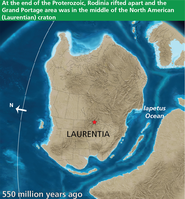
Paleogeographic Map of North America
550 Million Years Ago
Paleogeographic map of Laurentia (proto-North America) with location of Grand Portage National Monument marked with a red star.
At this time, the Proterozoic supercontinent,
Rodinia, was rifted apart and northern Minnesota was in the center of the North American (Laurentian) craton. The Paleoproterozoic sediments and Neoproterozoic volcanics were deeply buried.
Red star indicates approximate present-day location of Grand Portage National Monument.
Permission must be secured from the individual copyright owners to reproduce any copyrighted materials contained within this website. Digital assets without any copyright restrictions are public domain.
Graphic compiled by Trista L. Thornberry-Ehrlich (Colorado State University). Base paleogeographic map is from
“North American Key Time Slices” © 2013 Colorado Plateau Geosystems Inc., used under license.
Public domain:Minimum Granting Rights
Image
Grand Portage National Monument, Code: GRPO
Grand Portage National Monument, Cook County, Minnesota
Latitude: 47.999698638916, Longitude: -89.7606964111328
Latitude: 47.999698638916, Longitude: -89.7606964111328
01/01/0001
Public Can View
Tuesday, July 6, 2021 5:58:31 PM
Tuesday, July 6, 2021 5:58:31 PM
Figure_7_paleogeographic_map-01.jpg
Monday, January 1, 0001 12:00:00 AM
jpg
907.8 kB
Scenic