Select Item below to DOWNLOAD - Once item is selected, right click and choose 'save as'
d98df49599094c2e8a071195fb448c53
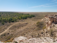
Point of Rocks overlooking trail trace at Cimarron National Grassland
A view from the top of a cliff, overlooking the plains.
Point of Rocks overlooking trail trace at Cimarron National Grassland ; https://www.fs.usda.gov/detail/psicc/about-forest/offices/?cid=fsm9_032733
U.S. National Park Service
Permission must be secured from the individual copyright owners to reproduce any copyrighted materials contained within this website.
Public domain
Kansas, (SanteFe Trail State)
Image
Santa Fe National Historic Trail, Code: SAFE
Elkhart ; Point of Rocks ; Cimarron National Grassland, Morton County, Kansas
Latitude: 37.1034952778, Longitude: -101.9384221
Santa Fe National Historic Trail
Latitude: 37.9892997741699, Longitude: -99.3414993286133
Latitude: 37.1034952778, Longitude: -101.9384221
Santa Fe National Historic Trail
Latitude: 37.9892997741699, Longitude: -99.3414993286133
20181005
10/05/2018
Shot On: SM-G930V; Dimensions 4032 x 3024; Shot 1/3200 sec. f/1.7 4.2mm; ISO 40; Size 6.2 MB
Public Can View
Organization: US National Park Service
Address: PO Box 728, Santa Fe, New Mexico 87504, Phone:(505) 988-6098
Email: ntir_information@NPS.gov
Address: PO Box 728, Santa Fe, New Mexico 87504, Phone:(505) 988-6098
Email: ntir_information@NPS.gov
Tuesday, November 3, 2020 4:32:07 PM
Tuesday, November 3, 2020 4:32:07 PM
SAFE_KS_CimarronNationalGrassland_20181005_NPS_(09).JPG
jpg
6.7 MB
Scenic
,
Historic