Select Item below to DOWNLOAD - Once item is selected, right click and choose 'save as'
d84d381491394d618c84ec6ab1420fc0
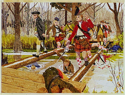
On February 27, 1776, Highlanders, ex-Regulators and other loyalist soldiers lead by Captain John Campbell attempted to cross a partially destroyed footbridge with greased girders at Moores Creek.
On February 27, 1776, Highlanders, ex-Regulators and other loyalist soldiers lead by Captain John Campbell attempted to cross a partially destroyed footbridge with greased girders at Moores Creek.
During the advance, the Loyalists were met with heavy musketry and artillery fire from the patriot militias under the command of Colonels Richard Caswell and Alexander Lillington.
Abbr=AVA
U.S. National Park Service
Reflective Art
Government owns art and all reproduction rights.
Public domain
Image
Moores Creek National Battlefield, Code: MOCR
Moores Creek National Battlefield, Pender County, North Carolina
Latitude: 34.4581985473633, Longitude: -78.1102981567383
Latitude: 34.4581985473633, Longitude: -78.1102981567383
Image Management System : IMS 03101
20190904
01/01/1973 - 12/30/1973
Image_Size=W: 12 15/16" x H: 10"; Metric_Size=W: 30.46CM X H: 25.38CM; AVA Project #30; Slide Show #178, Plate 27
H9
Public Can View
Organization: Harpers Ferry Center
Address: Harpers Ferry Center, 67 Mather Place, Harpers Ferry, WV, 25425, 304-535-5050
Address: Harpers Ferry Center, 67 Mather Place, Harpers Ferry, WV, 25425, 304-535-5050
Wednesday, October 9, 2019 12:50:04 PM
Wednesday, October 9, 2019 12:50:04 PM
03101.JPG
jpg
157.7 kB
Museum