Select Item below to DOWNLOAD - Once item is selected, right click and choose 'save as'
d6e8b2dc-b2b2-4e3c-99c4-bfdc8b804461
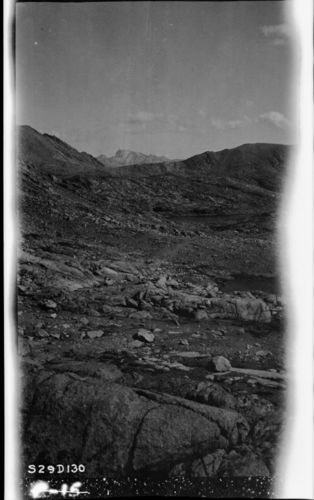
Trail routes, Alpine Fell-fields (Felsenmeer), looking southeast from a point just south of Mt. Ericson showing Mt. Whitney above ten miles by airline.
SEKI Historic Image
Trail routes, Alpine Fell-fields (Felsenmeer), looking southeast from a point just south of Mt. Ericson showing Mt. Whitney above ten miles by airline.
John Diehl, 290900, Upper Kern Basin, SNP, Trail routes, Alpine Fell-fields (Felsenmeer), looking southeast from a point just south of Mt. Ericson showing Mt. Whitney above ten miles by airline.
Permission must be secured from the individual copyright owners to reproduce any copyrighted materials contained within this website. Digital assets without any copyright restrictions are public domain.
Public domain
Image
Upper Kern Basin, Tulare County, California
09/01/1929
option 1
Public Can View
Wednesday, January 11, 2017 9:53:01 AM
Wednesday, January 11, 2017 9:53:01 AM
01275.tif
Monday, January 1, 0001 12:00:00 AM
tif
15.2 MB
Scenic
,
Historic