Select Item below to DOWNLOAD - Once item is selected, right click and choose 'save as'
d2977df8-6d29-4be7-8ead-f5a796a49545
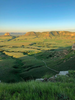
Dome Rock & South Bluff
Dome Rock & South Bluff in the distance with Saddle Rock Trail Below
Dome Rock & south bluff with Saddle Rock Trail Below
Permission must be secured from the individual copyright owners to reproduce any copyrighted materials contained within this website. Digital assets without any copyright restrictions are public domain.
Jestina Bortner
Public domain:Full Granting Rights
Image
Scotts Bluff National Monument, Code: SCBL
Scotts Bluff National Monument, Scotts Bluff County, Nebraska
Latitude: 41.8345985412598, Longitude: -103.707000732422
Latitude: 41.8345985412598, Longitude: -103.707000732422
01/01/2018
01/01/0001
Public Can View
Saturday, December 4, 2021 1:05:46 PM
Saturday, December 4, 2021 1:47:11 PM
2020. Photos of the Bluff. Dome Rock & Saddle Rock Trail Below. Jestina Bortner.jpg
Monday, January 1, 0001 12:00:00 AM
jpg
52.8 kB
Scenic