Select Item below to DOWNLOAD - Once item is selected, right click and choose 'save as'
cf3f341e-1240-4929-a420-75f3f92f6773
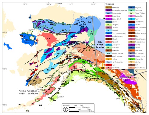
Terrane Map
Map showing the terranes of Alaska.
Map showing the terranes of Alaska. The Alaska Peninsula is underlain by the Peninsular terrane (PE).
The pre-Tertiary rocks of Katmai are a nearly complete section of the Peninsular terrane stratigraphy.
Permission must be secured from the individual copyright owners to reproduce any copyrighted materials contained within this website. Digital assets without any copyright restrictions are public domain.
Modified from
Silberling et al. (1992).
Public domain:Full Granting Rights
Image
Alagnak Wild River, Code: ALAG
Katmai National Park and Preserve, Code: KATM
Katmai National Park and Preserve, Code: KATM
Alagnak Wild River, Lake and Peninsula Borough, Alaska
Latitude: 59.003101348877, Longitude: -156.082000732422
Katmai National Park and Preserve, Alaska
Latitude: 58.5661087036133, Longitude: -154.889404296875
Latitude: 59.003101348877, Longitude: -156.082000732422
Katmai National Park and Preserve, Alaska
Latitude: 58.5661087036133, Longitude: -154.889404296875
01/01/0001
Public Can View
Thursday, September 2, 2021 12:55:00 PM
Thursday, September 2, 2021 2:56:07 PM
95_KATM_Fig Terrane map.jpg
Monday, January 1, 0001 12:00:00 AM
jpg
3.2 MB
Scenic