Select Item below to DOWNLOAD - Once item is selected, right click and choose 'save as'
c978584c-1230-4939-b879-640a0f5bb3ca
HOSP_11748_ArmyNavyHospitalCentralAveStreetView_1955
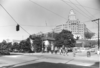
Glossy black & white photographic print, street scene; Photography of south end of Bathhouse Row and intersection of Reserve & Central Avenues; shows flag pole with flag flying in corner lawn of administration building, Lamar Bathhouse flag and antennae, south end of Buckstaff Bathhouse; Army-Navy Hospital with sign still in place over entrance, aerial walkway between hospital and Eastman Hotel annex; concrete boulevard in Central, telephone poles by Bathhouse Row; people passing on sidewalk along Bathhouse Row hedges
Glossy black & white photographic print, street scene; Photography of south end of Bathhouse Row and intersection of Reserve & Central Avenues; shows flag pole with flag flying in corner lawn of administration building, Lamar Bathhouse flag and antennae, south end of Buckstaff Bathhouse; Army-Navy Hospital with sign still in place over entrance, aerial walkway between hospital and Eastman Hotel annex; concrete boulevard in Central, telephone poles by Bathhouse Row; people passing on sidewalk along Bathhouse Row hedges
Permission must be secured from the individual copyright owners to reproduce any copyrighted materials contained within this website. Digital assets without any copyright restrictions are public domain.
National Park Service Picture – Courtesy of Hot Springs National Park Archives
Public domain:Full Granting Rights
Image
Hot Springs National Park, Code: HOSP
Hot Springs National Park, Garland County, Arkansas
Latitude: 34.511100769043, Longitude: -93.0896987915039
Latitude: 34.511100769043, Longitude: -93.0896987915039
1955
06/13/2016
Public Can View
Monday, July 20, 2020 12:00:32 PM
Monday, July 20, 2020 12:00:32 PM
HOSP 11748 small-jpg636014277129851692.jpg
Monday, June 13, 2016 9:15:11 PM
jpg
234.1 kB
Scenic