Select Item below to DOWNLOAD - Once item is selected, right click and choose 'save as'
C8EADD18-155D-4519-3E7F3AF8F25D8E7A
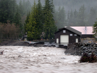
Erosion at Emergency Operations Center
A raging muddy river undercuts the edge of a building and pavement along its bank.
The Nisqually River carves away at the bank next to the Emergency Operations Center.
U.S. National Park Service
Permission must be secured from the individual copyright owners to reproduce any copyrighted materials contained within this website. Digital assets without any copyright restrictions are public domain.
Public domain:Full Granting Rights
Image
Mount Rainier National Park, Code: MORA
Mount Rainier National Park, Washington
Latitude: 46.865608215332, Longitude: -121.682601928711
Latitude: 46.865608215332, Longitude: -121.682601928711
7/16/2010 12:40:34 PM
Public Can View
Tuesday, January 2, 2018 10:44:44 AM
Monday, February 13, 2023 11:08:42 PM
C8EB0D32-155D-4519-3E4300EDF7F840B4.jpg
SONY SONY, DSC-S40
10/130 sec at f / 5.1
15.3 mm
ISO 160
Tuesday, November 7, 2006 4:39:03 PM
jpg
342.7 kB
Scenic