Select Item below to DOWNLOAD - Once item is selected, right click and choose 'save as'
c860d4b87b224af6953cf7b8acf2059f
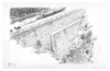
Illustration of an immense buttressed wall cradling the Chesapeake and Ohio Canal and towpath about 70 feet above the present Potomac River level near Widewater.
Illustration of an immense buttressed wall cradling the Chesapeake and Ohio Canal and towpath about 70 feet above the present Potomac River level near Widewater.
Illustration modified/corrected by artist under PX-1100-0-1271.; Abbr=WE
U.S. National Park Service
Reflective Art
Government owns art and all reproduction rights.
Public domain
Image
Chesapeake and Ohio Canal National Historical Park, Code: CHOH
Chesapeake and Ohio Canal National Historical Park
Latitude: 39.5996513366699, Longitude: -77.9448394775391
Latitude: 39.5996513366699, Longitude: -77.9448394775391
Image Management System : IMS 03420
20190904
01/01/1980 - 12/30/1980
Image_Size=21-11/16" x 14"; Exhibit 10/Graphic # 10-7
O 10
Public Can View
Organization: Harpers Ferry Center
Address: Harpers Ferry Center, 67 Mather Place, Harpers Ferry, WV, 25425, 304-535-5050
Address: Harpers Ferry Center, 67 Mather Place, Harpers Ferry, WV, 25425, 304-535-5050
Friday, October 4, 2019 2:41:31 PM
Friday, October 4, 2019 2:41:31 PM
03420.jpg
jpg
64.2 kB
Museum