Select Item below to DOWNLOAD - Once item is selected, right click and choose 'save as'
c65a4502-1d4a-4c7e-9eb8-ba35115eaa11
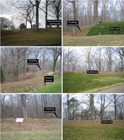
Photographs of Eroding Earthworks
Photographs of eroding earthworks. Earth surface processes are slowly muting the raised earthworks across the battlefield. Attempts to revegetate and stabilize the earthworks with sod have had mixed results.
The earthworks are among the most historically significant resources at Fort Donelson National Battlefield. Natural erosion, and human-induced erosion (e.g., climbing and social trail use) are denuding the
earthworks. The depressions shown are historic “trenches” behind the earthwork. The trenches are filling up with sediment. On hills, such as the central line of the outer works, the steep slopes serve like a fast
moving, down-hill rain gutter, eroding the earthwork, as well as eroding the historic trench or filling it with sediment. Restoration attempts (e.g., replacing sod) have been of mixed success. In 2018–2019 Youth Conservation Corps youth reconstructed check-dams to slow the water flow.
Permission must be secured from the individual copyright owners to reproduce any copyrighted materials contained within this website. Digital assets without any copyright restrictions are public domain.
Photographs by Trista L. Thornberry-Ehrlich (Colorado State University) taken in spring 2009.
Public domain:Full Granting Rights
Image
Fort Donelson National Battlefield, Code: FODO
Fort Donelson National Battlefield
Latitude: 36.4912986755371, Longitude: -87.8561325073242
Latitude: 36.4912986755371, Longitude: -87.8561325073242
01/01/0001
Public Can View
Tuesday, May 18, 2021 12:05:58 PM
Tuesday, May 18, 2021 12:05:58 PM
10_earthworks.jpg
Monday, January 1, 0001 12:00:00 AM
jpg
5.7 MB
Scenic