Select Item below to DOWNLOAD - Once item is selected, right click and choose 'save as'
c5cab24d-3c05-4f91-81f2-b1a8a17445cd
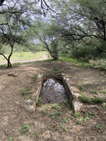
Compuerta and historic acequia
shallow brick-lined rectangular structure with narrow neck at one end
The compuerta acted as a check dam and holding area for water. Follow the line of the compuerta and trail beyond to see the original route of the acequia.
Permission must be secured from the individual copyright owners to reproduce any copyrighted materials contained within this website. Digital assets without any copyright restrictions are public domain.
NPS Photo
Public domain:Full Granting Rights
Image
Tumacacori National Historical Park, Code: TUMA
Tumacacori National Historical Park, Santa Cruz County, Arizona
Latitude: 31.5727996826172, Longitude: -111.047996520996
Latitude: 31.5727996826172, Longitude: -111.047996520996
08/22/2020
08/22/2020
Public Can View
Sunday, August 23, 2020 3:59:03 PM
Sunday, August 23, 2020 3:59:03 PM
2020 acequia-compuerta-full of water.JPG
Apple Apple, iPhone 11 32, iPhone 11 back dual wide camera 4.25mm f/1.8
1/485 sec at f / 1.8
4.25 mm
ISO 32
Saturday, August 22, 2020 3:59:09 PM
jpg
6.1 MB
Scenic