Select Item below to DOWNLOAD - Once item is selected, right click and choose 'save as'
c55f5a1b-55ab-4324-8457-272fe6e1da9a
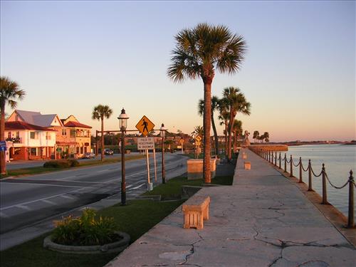
Promenade seawall at Castillo de San Marcos National Monument in January 2008
The concrete seawall, dating to the mid-to-late 1800s, runs from the edge of the older seawall (at the current parking lot) south to the Bridge of Lions. The first ±261'-7" (79.7m) of the seawall is NPS property (roughly where the turn-off from Florida A1A begins). The rest of the promenade belongs to the City of St. Augustine. There are 26 iron posts in the NPS section, plus one missing at the northern end. Some of the posts are replacements. The walkway is about 10'-6" (3.2m) wide.
view north along promenade toward the Castillo
The location of the promenade is 29°53'44.6"N, 81°18'39.2"W.
Permission must be secured from the individual copyright owners to reproduce any copyrighted materials contained within this website. Digital assets without any copyright restrictions are public domain.
Public domain
Image
Castillo de San Marcos National Monument, Code: CASA
Southeast Regional Office, Code: SERO
Southeast Regional Office, Code: SERO
Castillo de San Marcos National Monument, St. Johns County, Florida
Latitude: 29.8980369567871, Longitude: -81.3125
Latitude: 29.8980369567871, Longitude: -81.3125
01/14/2008
01/14/2008
Thursday, January 17, 2008 10:51:22 AM
Thursday, August 10, 2017 8:18:59 AM
CASA-f43641332e424cf6b501484a0ef8b219.jpg
NIKON NIKON, E3200
10/1712 sec at f / 2.8
5.8 mm
ISO 50
Monday, January 14, 2008 2:32:11 PM
jpg
146.8 kB
Promenade seawall at Castillo de San Marcos National Monument in January 2008
Promenade seawall at Castillo de San Marcos National Monument in January 2008
Promenade seawall at Castillo de San Marcos National Monument in January 2008
Promenade seawall at Castillo de San Marcos National Monument in January 2008
Promenade seawall at Castillo de San Marcos National Monument in January 2008