Select Item below to DOWNLOAD - Once item is selected, right click and choose 'save as'
bcc1a606-4fd4-4049-a168-5fe7ea828cb3
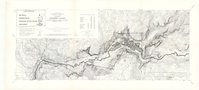
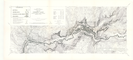
Existing Land Classification Yosemite National Park and Vicinity, Calif.
Existing Land Classification Yosemite National Park and Vicinity, Calif.
Topographic Map of Yosemite and surrounding area with regions distinguished by land classification
Item Number: YOSEAR000643B
Contact Yosemite National Park for more copyright information and use
Public domain:This digital asset is in the public domain. When using this asset for any purpose, including online, credit:'Courtesy U.S. National Parks'
Image
Yosemite National Park, Code: YOSE
Yosemite National Park, California
Latitude: 37.8399200439453, Longitude: -119.540397644043
Latitude: 37.8399200439453, Longitude: -119.540397644043
1958
01/01/1958 - 12/30/1958
Type: paper; Dimensions: 19.5 x 42.5 ; Condition: good
YOSE Location: E2 DR1 F1
Public Can View
Person: Archivist
Organization: US National Park Service
Address: Yosemite National Park Archives, PO Box 700-W, El Portal, CA 95318
Email: yose_archives@nps.gov
Organization: US National Park Service
Address: Yosemite National Park Archives, PO Box 700-W, El Portal, CA 95318
Email: yose_archives@nps.gov
Tuesday, July 26, 2022 1:44:10 PM
Tuesday, July 26, 2022 1:44:10 PM
YOSEAR000643B.tif
tif
122.9 MB
Scenic
,
Map