Select Item below to DOWNLOAD - Once item is selected, right click and choose 'save as'
ba0acd92-4d32-4f5c-9aed-adca21ab647c
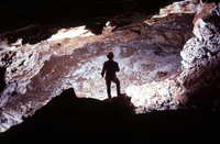
Yukon Trail
Caver inside the Yukon Trail
Named because the passage was heading north towards Alaska. Discovered and mapped by Dave Schnute, and Herb Conn and Jan Conn on December 2, 1964. Resurveyed on December 28, 1971 by Chris Hill, Dave Springhetti, and Lee Tierney.
Permission must be secured from the individual copyright owners to reproduce any copyrighted materials contained within this website. Digital assets without any copyright restrictions are public domain.
Public domain:Full Granting Rights
Image
Wind Cave National Park, Code: WICA
Wind Cave National Park, Custer County, South Dakota
Latitude: 43.5802993774414, Longitude: -103.439002990723
Latitude: 43.5802993774414, Longitude: -103.439002990723
01/01/2001
Public Can View
Friday, February 8, 2019 12:35:44 PM
Friday, February 8, 2019 12:35:44 PM
Room-Yukon_Trail.jpg
Monday, January 1, 0001 12:00:00 AM
jpg
37.6 kB
Scenic