Select Item below to DOWNLOAD - Once item is selected, right click and choose 'save as'
b7e0118d-4b98-48f0-a0e0-57eb18f4a497
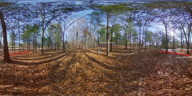
Parker's Revenge from the British View
A wooded and hilly landscape. Trees are bare. Ahead on a low hill are four blue rectangles with the words "Lexington militia" above them. Pan to the right you will see words "Rocky Outcrop. Pan to the right you will see two red rectangles and the words "British light infantry. Above them a series of white arrows showing the route of the Battle Road. To the right is Nelson Bridge. Panning further right is the word "Stream."
This shows the position of the Lexington militia as the British light infantry vanguard would have seen it as they crossed over Nelson Bridge during their retreat to Boston.
Permission must be secured from the individual copyright owners to reproduce any copyrighted materials contained within this website. Digital assets without any copyright restrictions are public domain.
NPS Photo
Public domain:Full Granting Rights
Image
Minute Man National Historical Park, Code: MIMA
Latitude: 42.4507666666667, Longitude: -71.2701638888889, Elevation: 68.91
Minute Man National Historical Park, Middlesex County, Massachusetts
Latitude: 42.4533996582031, Longitude: -71.2959976196289
Minute Man National Historical Park, Middlesex County, Massachusetts
Latitude: 42.4533996582031, Longitude: -71.2959976196289
11/19/2020
11/19/2020
Public Can View
Saturday, November 21, 2020 1:13:54 PM
Saturday, November 21, 2020 1:13:54 PM
British view try again.jpg
RICOH RICOH, RICOH THETA V
1/2500 sec at f / 2
1.3 mm
ISO 250
Thursday, November 19, 2020 6:39:52 PM
jpg
3.3 MB
Scenic