Select Item below to DOWNLOAD - Once item is selected, right click and choose 'save as'
b5a3cde3-a79c-4a96-a22f-326d20309129
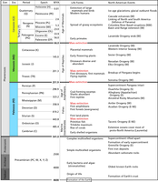
Geologic Time Scale
Geologic time scale showing the geologic eons, eras, periods, epochs, and associated dates in millions of years ago (MYA). The time scale also shows the onset of major evolutionary and tectonic events affecting the North American continent and the Northern Cordillera.
The divisions of the geologic time scale are organized stratigraphically, with the oldest divisions at the bottom and the youngest at the top. GRI map abbreviations for each time division are in parentheses.
Rocks and deposits of interest for the park are from the Precambrian (X and Y), Cretaceous Period (K),
Tertiary (T), and Quaternary Period (Q) (see table 1). Compass directions in parentheses indicate the regional locations of events. Boundary ages are millions of years ago (mya).
Permission must be secured from the individual copyright owners to reproduce any copyrighted materials contained within this website. Digital assets without any copyright restrictions are public domain.
NPS graphic using dates from the International Commission on Stratigraphy (http://www.stratigraphy.org/index.php/ics-chart-timescale; accessed 15 August 2018).
Public domain:Full Granting Rights
Image
Horseshoe Bend National Military Park, Code: HOBE
Horseshoe Bend National Military Park, Tallapoosa County, Alabama
Latitude: 32.9766998291016, Longitude: -85.7341003417969
Latitude: 32.9766998291016, Longitude: -85.7341003417969
02/27/2017
02/27/2017
Public Can View
Wednesday, May 26, 2021 1:19:43 PM
Wednesday, May 26, 2021 1:19:43 PM
Figure 4. Geo Time Scale FY17.jpg
Monday, February 27, 2017 3:52:18 PM
jpg
1.5 MB
Scenic