Select Item below to DOWNLOAD - Once item is selected, right click and choose 'save as'
b4b4cac8-ddf7-4cfe-b18f-ad199dcdd207
StoryMap 36: Respondents' Rated Appropriateness of Behaviors
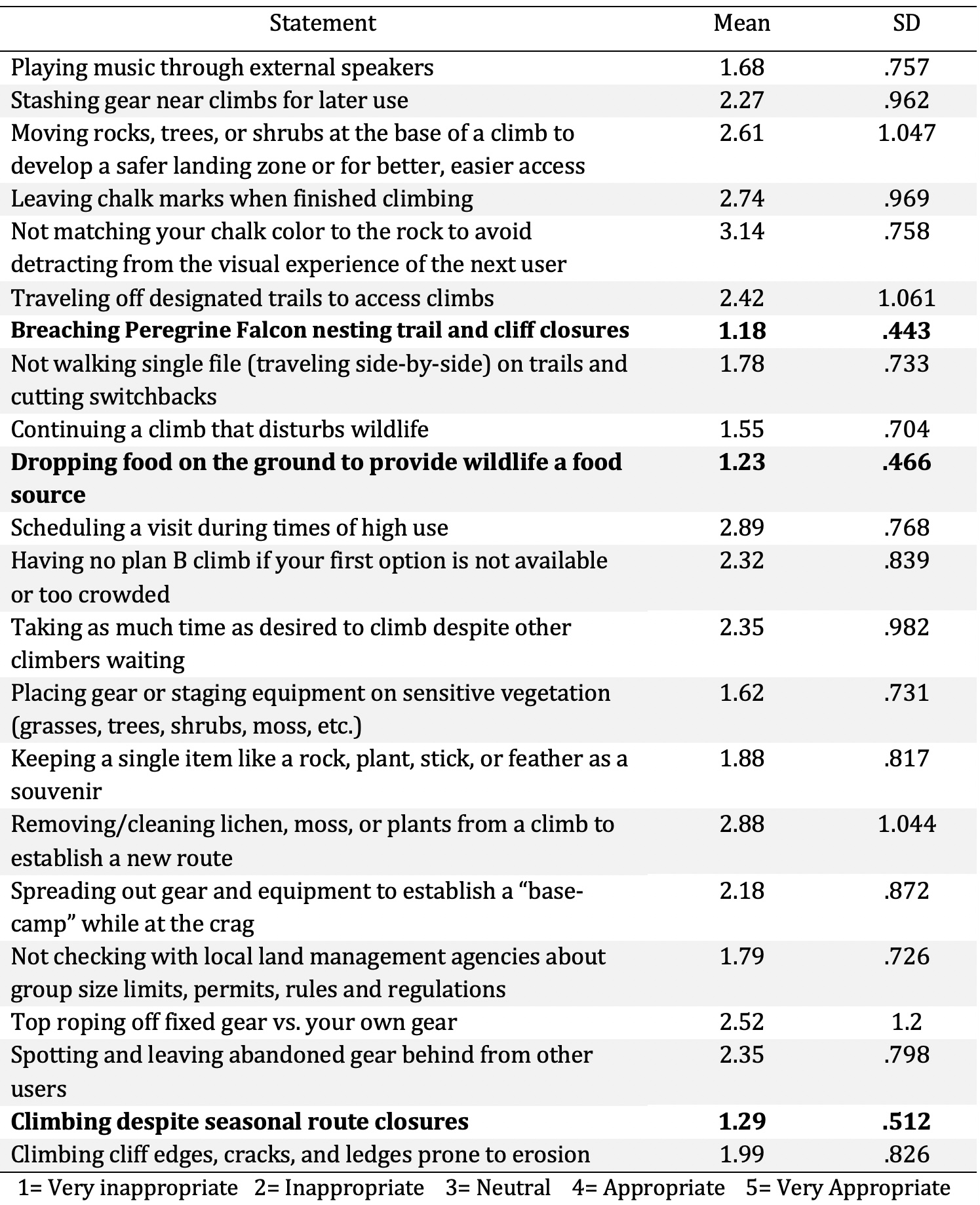
A table of respondent's rated appropriateness of behaviors where the most inappropriate behaviors for respondents on average were, “Breaching Peregrine Falcon nesting trail and cliff closures” (M = 1.18) and “Dropping food on the ground to provide wildlife a food source” (M = 1.23) (Table 6). The behavior with the most variance of appropriateness for respondents on average was, “Top roping off fixed gear vs. your own gear” (SD= 1.2).
This image was used in the "Harpers Ferry National Historical Park Climbing Study 2021" StoryMap (https://storymaps.arcgis.com/stories/162bfe6467f7436f8a2d293590dd0598).
That StoryMap reports research and outcomes of two-year mixed methods research conducted at Harpers Ferry National Historical Park (HAFE). This research intended to gather data and information to help support visitor use planning and management at HAFE. More specifically, this research provides information to understand climbing at and inform future management of climbing resources at HAFE. The research objectives focus on components of visitor use planning and management specific to HAFE that can benefit the most from this data and research.
This research is focused on rock climbers and climbing resources in the park with the purpose of 1) understanding representations of climbing activities and closures by Park staff and stakeholder groups, 2) disseminating a survey instrument to sample HAFE rock climbers regarding existing use and management perceptions and 3) informing the construction of a climbing management plan for HAFE.
National Park Service
This content was created under the agreement for the National Park Service. Image is available for public use, but attribution is required.
Old Dominion University
Public domain:Full Granting Rights
Image
Harpers Ferry National Historical Park, Code: HAFE
Harpers Ferry National Historical Park
Latitude: 39.312858581543, Longitude: -77.7419586181641
Latitude: 39.312858581543, Longitude: -77.7419586181641
https://storymaps.arcgis.com/stories/162bfe6467f7436f8a2d293590dd0598
https://irma.nps.gov/DataStore/Reference/Profile/2305435
https://irma.nps.gov/DataStore/Reference/Profile/2305435
StoryMap Originally Published on February 28, 2022
February 28, 2022 (StoryMap Publication Date)
The associated StoryMap was created by Old Dominion University and Kansas State University under agreements through the Chesapeake Watershed
Cooperative Ecosystem Studies Unit (CESU): P19AC01077 and P19AC00946.
Indefinite
Public Can View
Person: Cynthia Wanschura
Organization: National Capital Region, National Park Service
Role: NPGallery Asset Creator
Position: Regional GIS Specialist
Address: 1100 Ohio Drive, SW
Email: cynthia_wanschura@nps.gov
Person: Michala Hendrick, M.S.
Organization: Old Dominion University
Role: Primary StoryMap Creator
Position: Graduate Research Assistant (former)
Tuesday, August 27, 2024 9:51:28 PM
Wednesday, August 28, 2024 8:31:01 PM
36_BOVaKcvBxblZn-PK6tUbi.jpeg
jpeg
745.7 kB
Reports