Select Item below to DOWNLOAD - Once item is selected, right click and choose 'save as'
b384e2f0-a201-4980-ab7d-4d3627735904
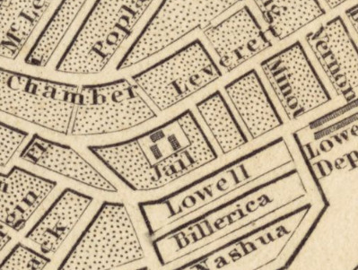
Leverett Street Jail, 1842 Map
Selection of a map with a jail marked in the center of it with city blocks around it.
This selection of the 1842 "Plan of the city of Boston" map shows the Leverett Street Jail in the center.
Norman B. Leventhal Map Center, Boston Public Library
Public domain:Boston Public Library, Norman B. Leventhal Map Center
Image
Boston African American National Historic Site, Code: BOAF
Boston African American National Historic Site, Suffolk County, Massachusetts
Latitude: 42.3578987121582, Longitude: -71.0706024169922
Latitude: 42.3578987121582, Longitude: -71.0706024169922
https://collections.leventhalmap.org/search/commonwealth:cj82m125r
01/01/1842
Public Can View
Organization: Norman B. Leventhal Map Center, Boston Public Library
Friday, November 13, 2020 2:35:19 PM
Friday, November 13, 2020 2:35:19 PM
LeverettStreetJail1842.png
png
246.7 kB
Historic
,
Map