Select Item below to DOWNLOAD - Once item is selected, right click and choose 'save as'
b05c89aa-06c0-42aa-9c90-06effe71be8c
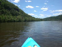
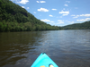
Delaware River Water Trail - Middle Delaware Segment Delaware Water Gap National Recreation Area
Kayaking on the Middle Delaware River
The Delaware River Water Trail follows one of the most remarkable rivers in the nation: so rich in recreational, scenic, historic and natural resources that three-quarters of the non-tidal Delaware River (about 150 miles) is included in the National Wild and Scenic Rivers System.
U.S. National Park Service
IN COPYRIGHT. This Item is protected by copyright and/or related rights. Copyright: John Bumberger
John Bumberger
Restrictions apply on use and/or reproduction:Copyrighted material
Image
National Trails System, Code: NTS
Delaware Water Gap National Recreation Area, Code: DEWA
Delaware Water Gap National Recreation Area, Code: DEWA
Connects Port Jervis to E. Stroudsburg in Delaware Water Gap NRA
Delaware Water Gap National Recreation Area
Latitude: 41.1003189086914, Longitude: -74.9569320678711
Delaware Water Gap National Recreation Area
Latitude: 41.1003189086914, Longitude: -74.9569320678711
12/29/2021 12:00:00 AM
12/29/2021
Public Can View
Person: John Bumberger
Organization: Delaware Water Gap National Recreation Area
Address: Bushkill, PA
Organization: Delaware Water Gap National Recreation Area
Address: Bushkill, PA
Friday, May 13, 2022 10:32:17 PM
Friday, May 13, 2022 10:32:17 PM
Delaware River Water Trail - Middle Delaware Segment 3.jpg
jpg
100.1 kB
Scenic