Select Item below to DOWNLOAD - Once item is selected, right click and choose 'save as'
adab1e03-be4f-4245-8246-907bb0d6533b
Harry S Truman National Historic Site
Main Brochure
Side 2
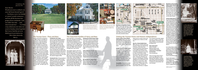
Images of Harry and Bess Truman, the Truman Farm Home, the Truman Home, the Noland Home, a map of the Independence area.
Side two of main brochure
Permission must be secured from the individual copyright owners to reproduce any copyrighted materials contained within this website. Digital assets without any copyright restrictions are public domain.
NPS and Truman Library
Public domain:Full Granting Rights
Image
Harry S. Truman National Historic Site, Code: HSTR
Harry S. Truman National Historic Site, Jackson County, Missouri
Latitude: 38.9012985229492, Longitude: -94.5307006835938
Latitude: 38.9012985229492, Longitude: -94.5307006835938
01/01/0001
Public Can View
Friday, July 23, 2021 10:32:34 AM
Friday, July 23, 2021 10:37:00 AM
HSTR Unigrid S 1-page-001.jpg
Monday, January 1, 0001 12:00:00 AM
jpg
906.3 kB
Scenic