Select Item below to DOWNLOAD - Once item is selected, right click and choose 'save as'
a6c6ff5aed4b4e09ab85200e1b6153a4
HPC-000135.jpg
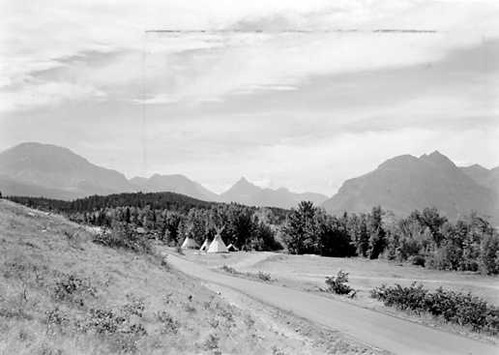
Blackfeet Highway at north end of St. Marys Junction Settlement, Glacier National Park. View is in direction of Red Eagle Valley and shows split at Red Eagle Mountains. (Blackfeet Tepees are visible in photo).
U.S. National Park Service
NO COPYRIGHT - UNITED STATES: The organization that has made the Item available believes that the Item is in the Public Domain under the laws of the United States, but a determination was not made as to its copyright status under the copyright laws of other countries. The Item may not be in the Public Domain under the laws of other countries. Please refer to the organization that has made the Item available for more information. Reference http://rightsstatements.org/vocab/NoC-US/1.0/
George A. Grant
Public domain
Ethnic Heritage-American Indian, (NPS History Collection Themes)
, Scenic Views, (NPS History Collection Themes)
, Transportation, (NPS History Collection Themes)
, fix, (NPS Focus Subject Thesaurus)
, Scenic Views, (NPS History Collection Themes)
, Transportation, (NPS History Collection Themes)
, fix, (NPS Focus Subject Thesaurus)
Image
Glacier National Park, Code: GLAC
Glacier National Park, Montana
Latitude: 48.7467994689941, Longitude: -113.858703613281
Latitude: 48.7467994689941, Longitude: -113.858703613281
NPS Museum Number Catalog : HFCA 1607
Title: Harpers Ferry Center
URL: https://www.nps.gov/subjects/hfc/nps-history-collection.htm
Title: Copyright
URL: http://rightsstatements.org/vocab/NoC-US/1.0/
URL: https://www.nps.gov/subjects/hfc/nps-history-collection.htm
Title: Copyright
URL: http://rightsstatements.org/vocab/NoC-US/1.0/
1940
Public Can View
Organization: National Park Service History Collection
Address: Harpers Ferry Center, PO Box 50, Harpers Ferry, WV, 25425, 304-535-6119
Email: HFC_Archivist@nps.gov
Address: Harpers Ferry Center, PO Box 50, Harpers Ferry, WV, 25425, 304-535-6119
Email: HFC_Archivist@nps.gov
Tuesday, July 20, 2021 6:44:08 PM
Tuesday, July 20, 2021 6:44:08 PM
hpc-000135_U.jpg
jpg
24.0 kB
Historic