Select Item below to DOWNLOAD - Once item is selected, right click and choose 'save as'
a5cfff96-49f0-4096-a501-4a7021fe10c1
June 22, Little Round Top Update
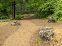
A brown path with topsoil and straw on either side winds through trees and rocks towards a road.
The path through the trees follows the original footprint of Sykes Avenue when the main form of transportation around the battlefield was via horse and buggy. The modern Sykes Avenue can be seen in the distance.
Permission must be secured from the individual copyright owners to reproduce any copyrighted materials contained within this website. Digital assets without any copyright restrictions are public domain.
NPS Photo
Public domain:Full Granting Rights
Image
Gettysburg National Military Park, Code: GETT
Gettysburg National Military Park, Adams County, Pennsylvania
Latitude: 39.804500579834, Longitude: -77.2384033203125
Latitude: 39.804500579834, Longitude: -77.2384033203125
06/22/2023
06/22/2023
Public Can View
Monday, June 26, 2023 4:11:25 PM
Monday, June 26, 2023 4:24:31 PM
Jason_6-22-23_0021.jpg
Canon Canon, Canon EOS 60D 1000, EF24-105mm f/4L IS II USM
1/800 sec at f / 4
24 mm
ISO 1000
Thursday, June 22, 2023 3:04:19 PM
jpg
1.7 MB
Scenic