Select Item below to DOWNLOAD - Once item is selected, right click and choose 'save as'
a48b6841-d1ab-42ee-bf6b-870e3dcf1be1
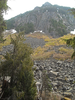
Eagle Peak and talus slope viewed from the trail to Carter Falls.
A rocky peak above cliffs and a large scree slope dotted with shrubs.
Eagle Peak and talus slope viewed from the trail to Carter Falls.
Permission must be secured from the individual copyright owners to reproduce any copyrighted materials contained within this website. Digital assets without any copyright restrictions are public domain.
NPS/C. Roundtree
Public domain:Full Granting Rights
Image
Mount Rainier National Park, Code: MORA
Mount Rainier National Park, Washington
Latitude: 46.865608215332, Longitude: -121.682601928711
Latitude: 46.865608215332, Longitude: -121.682601928711
06/07/2018
01/01/2001
Public Can View
Wednesday, March 13, 2019 12:57:20 PM
Tuesday, November 1, 2022 10:44:01 PM
CarterFalls Eagle Peak CRoundtree 6-7-18.jpg
Monday, January 1, 0001 12:00:00 AM
jpg
208.5 kB
Scenic