Select Item below to DOWNLOAD - Once item is selected, right click and choose 'save as'
a10b78e7-1b3c-4017-b5ce-0f25b484a64d
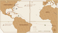
Possible Route of Angela
A conjectural map of Angela's voyage, Africa to Virginia
This is a conjectural map of the possible route of Angela, Africa to Virginia
Permission must be secured from the individual copyright owners to reproduce any copyrighted materials contained within this website. Digital assets without any copyright restrictions are public domain.
Public domain:Full Granting Rights
Image
Colonial National Historical Park, Code: COLO
Colonial National Historical Park, Virginia
Latitude: 37.2880897521973, Longitude: -76.6342163085938
Latitude: 37.2880897521973, Longitude: -76.6342163085938
08/21/2019
08/21/2019
Public Can View
Person: Dave Frederick
Organization: National Park Service
Role: ESRI Story Map
Position: GIS Specialist
Address: PO Box 210 Yorktown VA 23690
Email: dave_frederick@nps.gov
Organization: National Park Service
Role: ESRI Story Map
Position: GIS Specialist
Address: PO Box 210 Yorktown VA 23690
Email: dave_frederick@nps.gov
Thursday, August 22, 2019 12:46:23 PM
Thursday, August 22, 2019 12:46:23 PM
Angela route.jpg
Wednesday, August 21, 2019 9:42:34 PM
jpg
1.7 MB
Scenic