Select Item below to DOWNLOAD - Once item is selected, right click and choose 'save as'
The National Park Service is committed to making its electronic and information technologies accessible to individuals with disabilities.
If you require assistance or wish to report an issue related to the accessibility of any content on this website, please email NPGallery@nps.gov
If you require assistance or wish to report an issue related to the accessibility of any content on this website, please email NPGallery@nps.gov
9fe2fe28-43af-4574-8dde-2555a2657aca
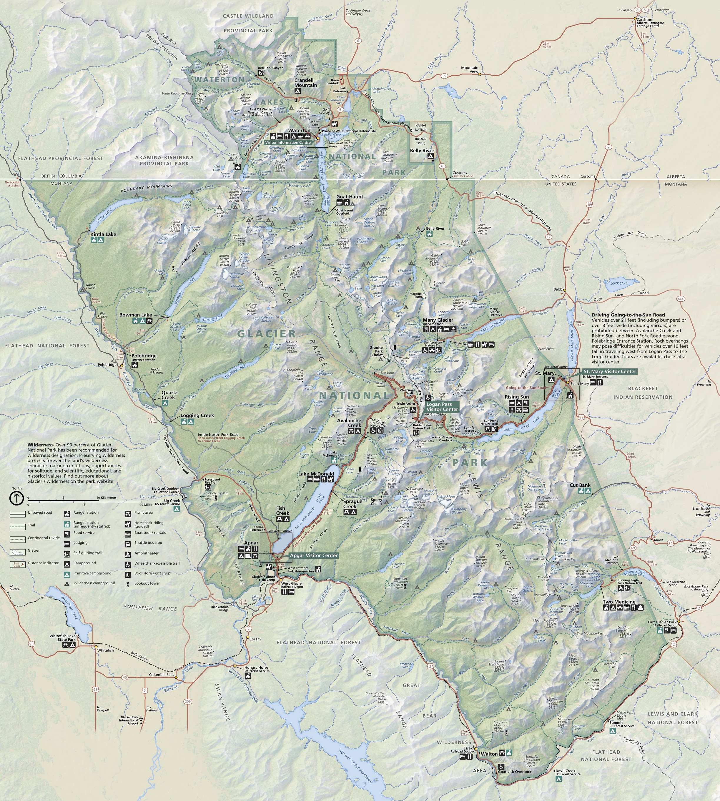
Park Map - Glacier National Park
Map of Glacier National Park in Montana. Shown in sage green as a roughly trapezoidal area, the park stretches diagonally from the northwest to the southeast through the center of the map region, with a small and craggy appendage of green extending even further north to encompass Waterton Lakes National Park in Alberta, Canada. Hundreds of beige glaciers and mountain ridges, powder blue waterways, color-coded campgrounds, brown roads, and other sites are labeled across the landscape.
Screen-viewable file; Adobe print production files can be downloaded from the Compressed zip Version link
Map Projection: WM; Map Type: park map
U.S. National Park Service
The National Park Service maps are government produced and are in the public domain. Anyone may, without restriction under U.S. copyright laws: Reproduce the work in print or digital form; Create derivative works; Perform the work publicly; Display the work; Distribute copies or digitally transfer the work to the public by sale or other transfer of ownership, or by rental, lease, or lending. Please note, a user who modifies and/or republishes National Park Service maps are responsible for any problems encountered with the maps, due to their change or modification.
Public domain
Document
Glacier National Park, Code: GLAC
Glacier National Park, Montana
Latitude: 48.7467994689941, Longitude: -113.858703613281
Latitude: 48.7467994689941, Longitude: -113.858703613281
2022-06-10
06/10/2022
Public Can View
Person: Harpers Ferry Center
Organization: US National Park Service
Address: Harpers Ferry Center, Harpers Ferry, WV
Email: HFC_Cartography@nps.gov
Organization: US National Park Service
Address: Harpers Ferry Center, Harpers Ferry, WV
Email: HFC_Cartography@nps.gov
Monday, June 5, 2023 10:25:33 PM
Friday, September 26, 2025 11:35:24 PM
GLACmap1.pdf
pdf
184.3 MB
Map