Select Item below to DOWNLOAD - Once item is selected, right click and choose 'save as'
9BC41108-D627-CBAA-B1F484721DB24C77
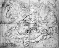
Map of the Battlefield from 1865
A drawn map shows the roads, topography, and troop positions around the Appomattox Court House Village.
A map of the battlefield from 1865 shows the positions of the opposing forces on the Appomattox Court House Landscape. The Civil War battle at Appomattox was fought in April, 1865, culminating in General Robert E. Lee's surrender of the Army of Northern Virginia which was the beginning of the end of the Civil War. The landscape's topography, structures and roads, and subsequent period of commemoration are all associated with this significant battle event.
U.S. National Park Service
Permission must be secured from the individual copyright owners to reproduce any copyrighted materials contained within this website. Digital assets without any copyright restrictions are public domain.
NPS Photo, APCO Archives, File 229
Public domain:Full Granting Rights
Image
Appomattox Court House National Historical Park, Code: APCO
Latitude: 37.37756, Longitude: -78.79605
Appomattox Court House National Historical Park, Appomattox County, Virginia
Latitude: 37.3827018737793, Longitude: -78.8009033203125
Appomattox Court House National Historical Park, Appomattox County, Virginia
Latitude: 37.3827018737793, Longitude: -78.8009033203125
1865
Public Can View
Person: lnigro
Tuesday, September 8, 2020 9:59:00 AM
Tuesday, September 8, 2020 9:59:00 AM
9BC9C8A8-0B9B-2924-2308A03658BF33F0.JPG
Monday, January 1, 0001 12:00:00 AM
jpg
92.0 kB
Scenic