Select Item below to DOWNLOAD - Once item is selected, right click and choose 'save as'
9628f2f4-c221-4f45-9141-0d983052f117
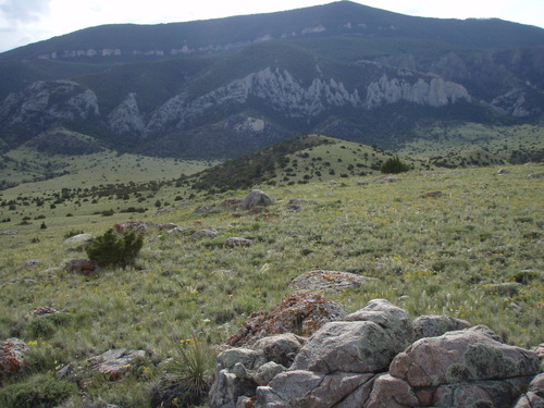
BICA_LTM_Veg010_PP02_2017_W.JPG
GRYN Vegetation Monitoring Photo Point 2.
BICA long-term monitoring data frame 10, taken on an Olympus Digital Camera.
Naming convention = Bighorn Canyon National Recreation Area + long-term monitoring+ Data frame # + Photo point # + year taken + direction facing.
Arista Regalia, IMR GIS Assistant.
arista_regalia@partner.nps.gov
Permission must be secured from the individual copyright owners to reproduce any copyrighted materials contained within this website. Digital assets without any copyright restrictions are public domain.
Public domain:Full Granting Rights
Image
Greater Yellowstone Network, Code: GRYN
Bighorn Canyon National Recreation Area, Code: BICA
Bighorn Canyon National Recreation Area, Code: BICA
NAD83 UTM Zone 12T, Bighorn Canyon National Recreation Area
Latitude: 5002261, Longitude: 715901
Latitude: 5002261, Longitude: 715901
06/01/2017
06/01/2017
Public Can View
Person: Rob Daley
Organization: NPS GRYN
Role: Data Manager
Email: rob_daley@nps.gov
Person: Arista Regalia
Organization: NPS IMR
Role: GIS Assistant
Email: arista_regalia@partner.nps.gov
Organization: NPS GRYN
Role: Data Manager
Email: rob_daley@nps.gov
Person: Arista Regalia
Organization: NPS IMR
Role: GIS Assistant
Email: arista_regalia@partner.nps.gov
Tuesday, February 14, 2023 7:18:16 PM
Thursday, June 29, 2023 9:02:30 PM
BICA_LTM_Veg010_PP02_2017_W.JPG
OLYMPUS IMAGING CORP. OLYMPUS IMAGING CORP., u770SW,S770SW
1/640 sec at f / 3.5
6.7 mm
ISO 80
Thursday, June 1, 2017 4:42:35 PM
jpg
734.4 kB
Monitoring