Select Item below to DOWNLOAD - Once item is selected, right click and choose 'save as'
94f27a82afa74d44885ebdd061bd3433
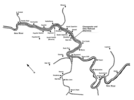
Map depicts the Mainline of the Chesapeake and Ohio Railroad as well as several railroad spurs, mines, and towns along the New River in West Virginia.
Map depicts the Mainline of the Chesapeake and Ohio Railroad as well as several railroad spurs, mines, and towns along the New River in West Virginia.
Abbr=EX
U.S. National Park Service
Project=Canyon Rim Visitor Center; Art_Registration_No=EPD-0027 ; Reflective Art
Government owns art and all reproduction rights.
Public domain
Image
New River Gorge National Park and Preserve, Code: NERI
New River Gorge National Park and Preserve, West Virginia
Latitude: 37.840259552002, Longitude: -80.9897079467773
Latitude: 37.840259552002, Longitude: -80.9897079467773
Image Management System : IMS 10222
20190904
01/01/1990 - 12/30/1990
Exhibit 7/Graphic # NE-G-706a
Q9
Public Can View
Organization: Harpers Ferry Center
Address: Harpers Ferry Center, 67 Mather Place, Harpers Ferry, WV, 25425, 304-535-5050
Address: Harpers Ferry Center, 67 Mather Place, Harpers Ferry, WV, 25425, 304-535-5050
Monday, October 7, 2019 2:34:07 PM
Monday, October 7, 2019 2:34:07 PM
10222.jpg
jpg
59.6 kB
Museum