Select Item below to DOWNLOAD - Once item is selected, right click and choose 'save as'
91d25ca8-3946-4938-a493-d5e8bc36183c
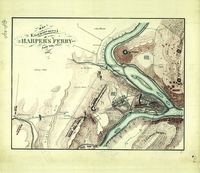
Harper’s Ferry, West Virginia
A yellowed hand-drawn map of a river town is overlaid with opposing battle lines and troop movements.
Pen-and-ink and pencil (some color), bound in “Report of the camps, marches & engagements, of the Second Corps…and of the Army of the Valley…during the campaign of 1864/ illustrated by maps & sketches by Jed. Hotchkiss” (approximately 24 x 24 inches)
Permission must be secured from the individual copyright owners to reproduce any copyrighted materials contained within this website. Digital assets without any copyright restrictions are public domain.
Public domain:Full Granting Rights
Image
Cedar Creek and Belle Grove National Historical Park, Code: CEBE
Cedar Creek and Belle Grove National Historical Park, Virginia
Latitude: 38.9937210083008, Longitude: -78.3142166137695
Latitude: 38.9937210083008, Longitude: -78.3142166137695
03/04/2013
03/04/2013
Public Can View
Friday, December 10, 2021 7:31:45 AM
Friday, December 10, 2021 7:47:09 AM
No8-12a_ca000017-v3.tif
Monday, March 4, 2013 9:35:46 PM
tif
29.9 MB
Scenic