Select Item below to DOWNLOAD - Once item is selected, right click and choose 'save as'
8ff5f673-b5f1-45d4-b66c-b0348fcd7eb3
Stratigraphic Columns
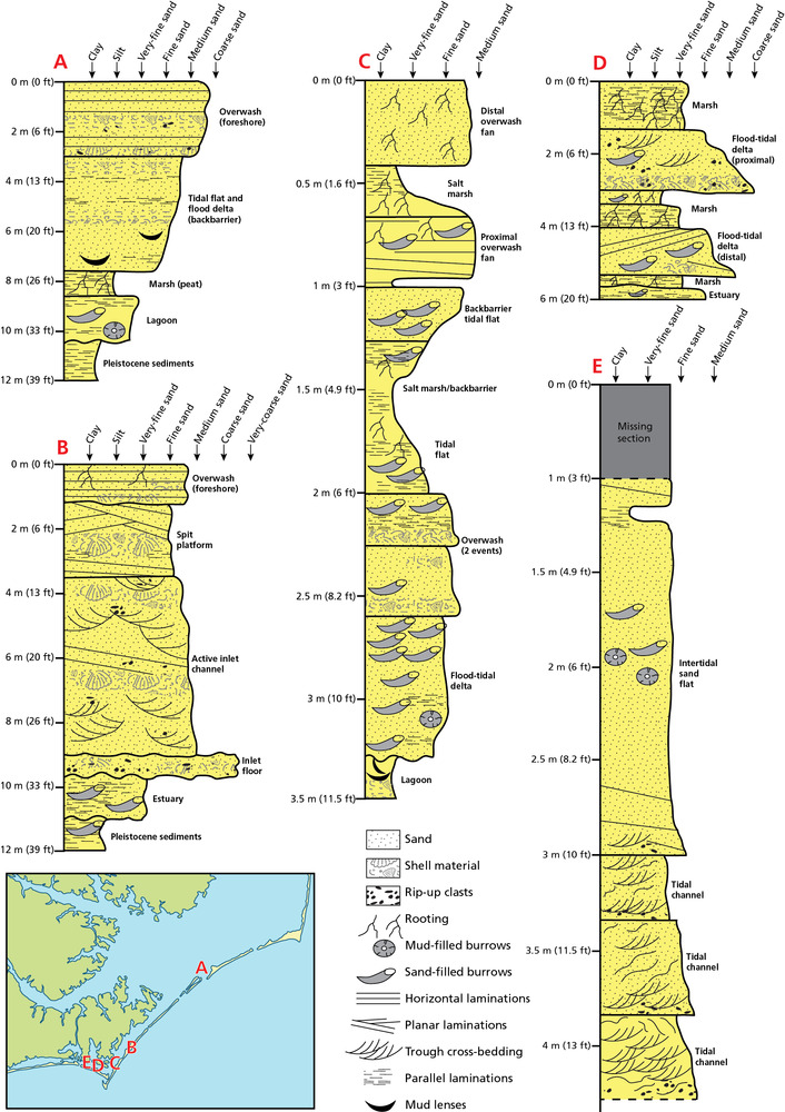
Vertical sequences of shallow sediments below the park. Figure has 5 cross sections that show sand, shell material, rip-up clasts, rooting, mud- or sand- filled burrows, horizontal laminations, planar laminations, trough cross bedding, parallel laminations, and/or mud lenses, in addition to relative size of clasts.
Vertical sequences of shallow sediments below the park. See figure 6 for cross-sections of the
underlying sediments. (A) Composite vertical sequence of Holocene and Pleistocene sediments for the Portsmouth area
of North Core Banks (after figure 10 from Heron et al. 1984). (B) South Core Banks sedimentary sequence of Johnson
Creek relict inlet fill is a fining-upward wave-dominated inlet sequence of cross-bedded sand and shell (after figure
2.16 from Moslow and Heron 1994). (C) Stratigraphy from back-barrier margin of South Core Banks. The basal unit is
a burrowed and ripple-laminated silty sand to silty clay of back-barrier origin. It has an abrupt erosional contact with
fine grained sand from an overlying flood-tidal delta. Overlying this is several interbedded units of proximal and distal
overwash and back-barrier salt marsh and tidal flat deposits (after figure 2.15 from Moslow and Heron 1994). (D) The
Back Sound back-barrier sequence from “Middle Marsh” has two stacked, fining-upward flood tidal delta sequences,
interbedded and overlain by thin layers of salt-marsh muds (after figure 2.18 from Moslow and Heron 1994). (E)
Stratigraphy of intertidal sand flat in Back Sound (after figure 2.19 from Moslow and Heron 1994).
Permission must be secured from the individual copyright owners to reproduce any copyrighted materials contained within this website. Digital assets without any copyright restrictions are public domain.
All graphics by Trista L. Thornberry-Ehrlich (Colorado State University) based on figures cited in caption.
Public domain:Full Granting Rights
Image
Cape Lookout National Seashore, Code: CALO
Cape Lookout National Seashore, Carteret County, North Carolina
Latitude: 34.9581985473633, Longitude: -76.1900024414063
Latitude: 34.9581985473633, Longitude: -76.1900024414063
01/01/0001
Public Can View
Thursday, August 5, 2021 10:44:57 AM
Thursday, August 5, 2021 1:02:23 PM
10_CALO_StratigraphicColumns_0106-2017_tte-01.jpg
Monday, January 1, 0001 12:00:00 AM
jpg
2.3 MB
Scenic