Select Item below to DOWNLOAD - Once item is selected, right click and choose 'save as'
8E10AF92D24E40BDB0445FB8EED646B5
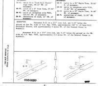
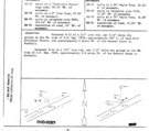
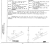
00004097 Monumentation Sketch of B-13 in Delaware Water Gap National Recreation Area, 1966
00004097 Monumentation Sketch of B-13 in Delaware Water Gap National Recreation Area, 1966
Sketch map of survey monument and immediate area.
U. S. National Park Service
Set By NGS
This digital asset is in the public domain. When using this asset for any purpose, including online, credit: 'U.S. National Park Service, Land Resources Division'.
NPS / Tim Smith
Public domain
Image
Delaware Water Gap National Recreation Area, Code: DEWA
Delaware Water Gap National Recreation Area
Latitude: 41.1003189086914, Longitude: -74.9569320678711
Latitude: 41.1003189086914, Longitude: -74.9569320678711
MONUMENTID for Monuments : 00004097
2015/07/20
Public Can View
Organization: Land Resources Division
Position: Program Coordinator
Address: 1849 C Street, NW, Suite 2340, Main Interior Building, Washington, DC 20240
Position: Program Coordinator
Address: 1849 C Street, NW, Suite 2340, Main Interior Building, Washington, DC 20240
Monday, September 23, 2024 6:05:55 PM
Monday, September 23, 2024 6:05:55 PM
00004097.gif
gif
44.2 kB
Monitoring
,
Inventory
,
Map