Select Item below to DOWNLOAD - Once item is selected, right click and choose 'save as'
8b123a5c-3837-4ab1-bdc5-07675e927b0d
WetlandCharacteristics_Cropped.png
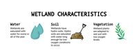
Three illustrations read from left to right and demonstrate the three characteristics of wetlands discovered by the computer model. The variables include water, soil, and vegetation.
The first illustration: Two teal-colored rain drops, one on top of the other with a slight offset represent water. The text to the left of the illustration reads “Wetlands are saturated with water for some or all of the year.”
The second illustration: Brown mounds of soil with a shovel placed in the dirt represents the wetland characteristic “soil.” The text to the left of the illustration reads “Wetlands have hydric soils. Hydric soils are saturated with water long enough for low oxygen conditions to occur.”
The third illustration: A small green branch sprouts green and yellow leaves along the entire stem and represents the wetland characteristic “vegetation.” The text to the left of the illustration reads “Wetland plants are adapted to wet soil with low oxygen levels.”
Illustrations of the three wetland characteristics in Great Smoky Mountain National Park.
Permission must be secured from the individual copyright owners to reproduce any copyrighted materials contained within this website. Digital assets without any copyright restrictions are public domain.
Kathryn Nuessly
Public domain:Minimum Granting Rights
Image
Great Smoky Mountains National Park, Code: GRSM
Great Smoky Mountains National Park
Latitude: 35.5715599060059, Longitude: -83.528190612793
Latitude: 35.5715599060059, Longitude: -83.528190612793
Public Can View
Tuesday, July 6, 2021 1:26:50 PM
Tuesday, July 6, 2021 1:26:50 PM
WetlandCharacteristics_Cropped.png
png
745.6 kB
Scenic