Select Item below to DOWNLOAD - Once item is selected, right click and choose 'save as'
89C83BCDD44148BA86A2034A8A16D84B
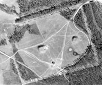
OCMU WPA Lamar Excavations Aerial
When excavations began, Lamar was open crop fields. This aerial was taken after the Levee excavations in 1938 but before work began on the palisade ditch in 1939. Some of the earlier excavations are fainter because they were backfilled with soil.
U. S. National Park Service
Scan of item in the SEAC archives. Intended for use with a public web map application.
Permission must be secured from the individual copyright owners to reproduce any copyrighted materials contained within this website. Digital assets without any copyright restrictions are public domain.
Public domain
Image
Ocmulgee Mounds National Historical Park, Code: OCMU
Ocmulgee Mounds National Historical Park, Bibb County, Georgia
Latitude: 32.839599609375, Longitude: -83.5970001220703
Latitude: 32.839599609375, Longitude: -83.5970001220703
ANCS-plus : SEAC-00125
07/01/2015
12/13/1933 - 03/05/1940
Public Can View
Person: Jill Halchin
Organization: US National Park Service
Position: GIS Coordinator
Address: Southeast Archeological Center, Tallahassee FL
Email: jill_halchin@nps.gov
Organization: US National Park Service
Position: GIS Coordinator
Address: Southeast Archeological Center, Tallahassee FL
Email: jill_halchin@nps.gov
Sunday, January 29, 2017 2:07:59 PM
Thursday, August 10, 2017 1:41:34 AM
LamarAerialcrop.tif
Monday, June 29, 2015 10:29:07 PM
tif
20.7 MB
Museum