Select Item below to DOWNLOAD - Once item is selected, right click and choose 'save as'
87e3a090-27c8-4926-af1a-7e61e4d0b120
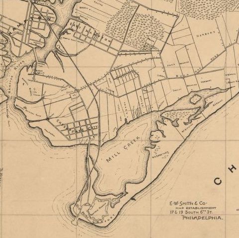
Map of Elizabeth City Co., Va., 1902
Map of Elizabeth County, Virginia, 1902.
Map of Elizabeth City Co., Va., cropped version. From actual surveys by E.A. Semple, Wm. Ivy and C. Hubbard (Edward Armistead Semple, William Ivy, and C. Hubbard)
Philadelphia : E. W. Smith and Co.
Semple, E. A, Wm Ivy, C Hubbard, and E.W. Smith & Co. Map of Elizabeth City Co., Va.: from actual surveys by E.A. Semple, Wm. Ivy and C. Hubbard. Philadelphia: E. W. Smith and Co, 1902. Map. https://www.loc.gov/item/2011588010/.
Credit: Library of Congress, Geography and Map Division
Public domain:The Library of Congress is providing access to these materials for educational and research purposes and is not aware of any U.S. copyright protection (see Title 17 of the United States Code) or any other restrictions in the Map Collection materials.
Image
Boston National Historical Park, Code: BOST
Boston National Historical Park, Suffolk County, Massachusetts
Latitude: 42.3734016418457, Longitude: -71.0557022094727
Latitude: 42.3734016418457, Longitude: -71.0557022094727
01/01/1902
Public Can View
Organization: Library of Congress
Thursday, May 7, 2020 6:37:49 AM
Thursday, May 7, 2020 6:37:49 AM
TEJ2-MapElizabethCounty.jpeg
jpeg
63.0 kB
Historic