NPS Museum Accession Number : ZION-00768
Zion Legacy HPC Database Number : HPC-007677
Organization: Zion National Park
Position: Museum Curator
Address: Zion National Park, State Route 9, Springdale, UT 84767
Email: zion_museum@nps.gov
Part of topographic map of Zion National Park, reduced to one half scale linear. ; ZION Museum and Archives Image ZION 10154 ; ZION 10154
Map of Zion Canyon pioneer homesteads. Artist Mary Tucker. ; ZION Museum and Archives Image ZION 13271 ; ZION 13271
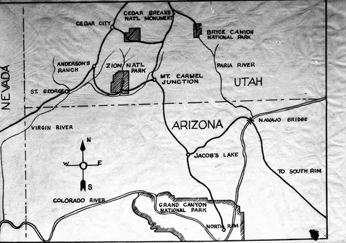
A map of southern Utah noting national parks and monuments. ; ZION Museum and Archives Image ZION 13387 ; ZION 13387
A map of northern Utah noting locations of national parks and monuments. ; ZION Museum and Archives Image ZION 13388 ; ZION 13388
Route of Father Escalante in 1776. ; ZION Museum and Archives Image ZION 13694 ; ZION 13694
Map of old Spanish Trail. ; ZION Museum and Archives Image ZION 13695 ; ZION 13695
Map of Zion National Park. ; ZION Museum and Archives Image ZION 13715 ; ZION 13715
Copy of topo map, Zion-Mt. Carmel Highway switchback section, enlarged for geologic study of mass wasting (slope movement). ; ZION Museum and Archives Image ZION 7543 ; ZION 7543
Copy of topo map of Blue Springs area, land condemned for park use - sections 30 and 31, T 39 S, R 10 W. ; ZION Museum and Archives Image ZION 8324 ; ZION 8324
Contour map of southern Utah. (history). ; ZION Museum and Archives Image ZION 9109 ; ZION 9109