Select Item below to DOWNLOAD - Once item is selected, right click and choose 'save as'
861bea2d09b64e169a837fe0f16bebb8
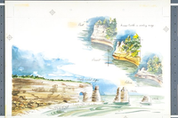
Illustration montage depicts a typical Pictured Rocks shoreline with idealized eroded features of cliffs, caves, and stacks; and a three-part conceptual view of the erosional development of Miners Castle.
Illustration montage depicts a typical Pictured Rocks shoreline with idealized eroded features of cliffs, caves, and stacks; and a three-part conceptual view of the erosional development of Miners Castle.
Artist was employee of the National Park Service (Harpers Ferry Center).; Abbr=WE
U.S. National Park Service
Project=Miners Castle; Reflective Art
Government owns art and all reproduction rights.
Public domain
Image
Pictured Rocks National Lakeshore, Code: PIRO
Pictured Rocks National Lakeshore, Alger County, Michigan
Latitude: 46.513500213623, Longitude: -86.4669036865234
Latitude: 46.513500213623, Longitude: -86.4669036865234
Image Management System : IMS 04639
20190904
01/01/1978 - 12/30/1978
Exhibit 3: "Lakeshore Architecture": Graphic # 3-5 and Graphic # 3-6
I 10
Public Can View
Organization: Harpers Ferry Center
Address: Harpers Ferry Center, 67 Mather Place, Harpers Ferry, WV, 25425, 304-535-5050
Address: Harpers Ferry Center, 67 Mather Place, Harpers Ferry, WV, 25425, 304-535-5050
Friday, October 4, 2019 2:20:37 PM
Friday, October 4, 2019 2:20:37 PM
04639.JPG
jpg
60.4 kB
Museum