Select Item below to DOWNLOAD - Once item is selected, right click and choose 'save as'
82e8ef8c-b65e-4e3f-b380-ca2641499f23
First Claimant Testimony, page 2
Scanned image of form. See description for text.
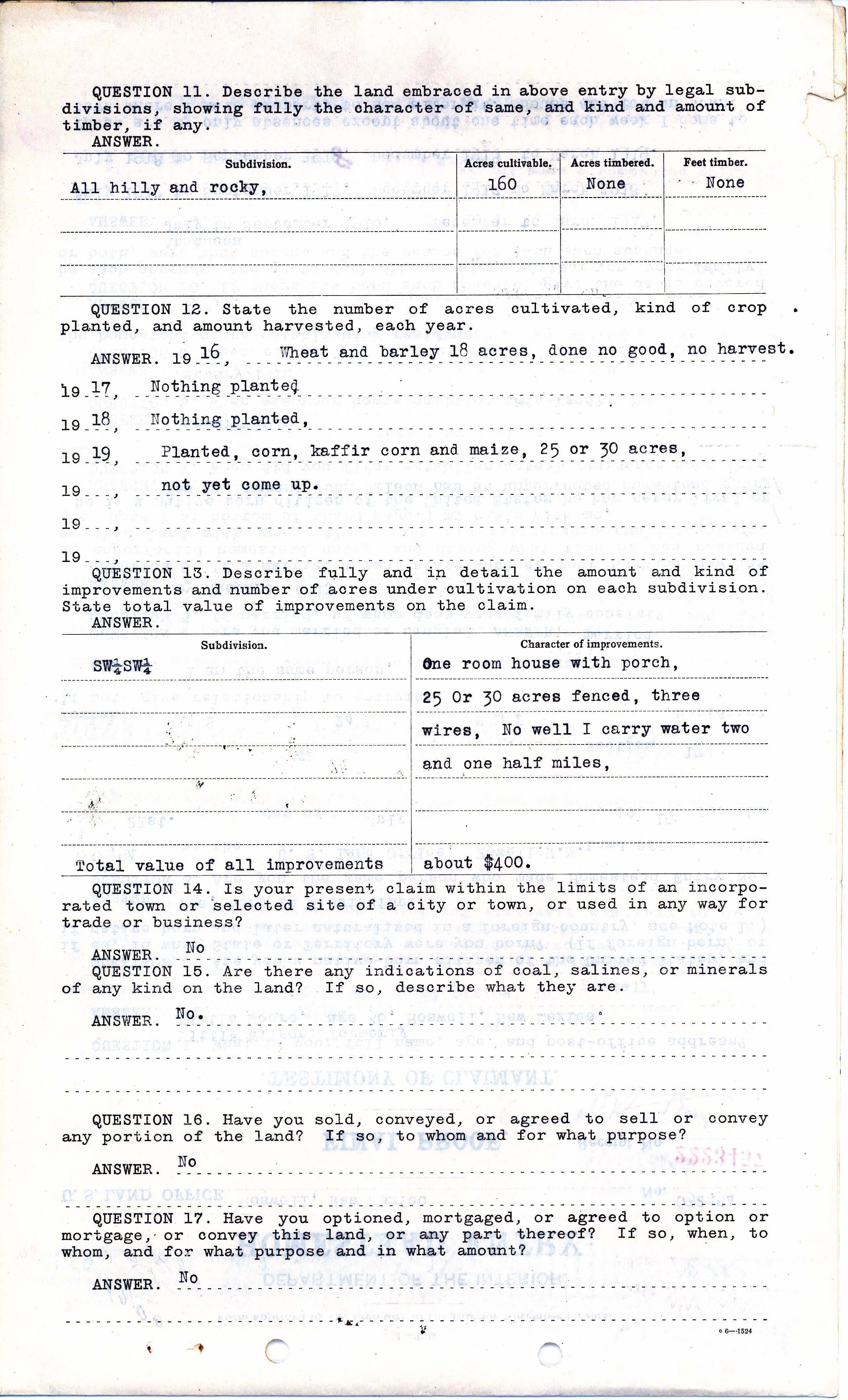
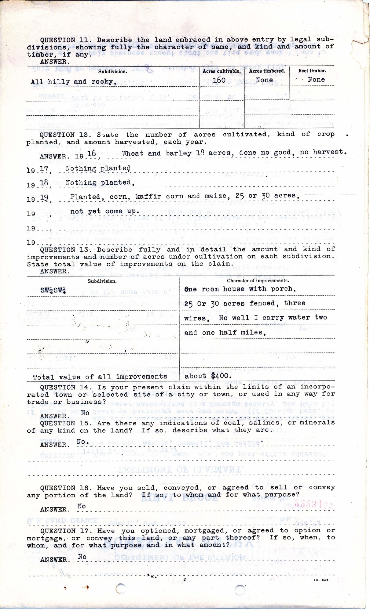
QUESTION 11. Describe the land embraced in above entry by legal subdivisions, showing fully the character of same, and kind and amount of timber, if any.
ANSWER.
Subdivision Acres cultivatable Acres timbered Feet timber
All hilly and rocky. 160 None None
QUESTION 12. State the number of acres cultivated, kind of crop planted, and amount harvested each year.
ANSWER. 1916, Wheat and barley 18 acres, done no good, no harvest.
1917, Nothing planted,
1918, Nothing planted,
1919, Planted, corn, kaffir corn and maize, 25 or 30 acres, not yet come up.
QUESTION 13. Describe fully and in detail the amount and kind of improvements and number of acres under cultivation on each subdivision. State total value of improvements on the claim.
ANSWER.
Subdivision. Character of Improvements.
SW ¼ of SW ¼ One room house and porch 25 or 30 acres,
20 Or 30 acres fenced, three wires, No well I carry water two and one half miles,
Total value of all improvements about $400.
QUESTION 14. Is your present claim within the limits of an incorporated town or selected site of a city or town, or used in any way for trade or business?
ANSWER. No
QUESTION 15. Are there any indications of coal salines, or minerals of any kind on the land? If so, describe what they are.
ANWSER. No
QUESTION 16. Have you sold, conveyed, or agreed to sell or convey any portion of the land; if so, to whom and for what purpose?
ANSWER. No.
QUESTION 17. Have you optioned, mortgaged, or agreed to option or mortgage, or convey this land, or any part thereof; if so, when, to whom, and for what purpose and in what amount?
ANSWER. No.
Federal records are in the public domain
Public domain
Document
Homestead National Historical Park, Code: HOME
Homestead National Historical Park, Gage County, Nebraska
Latitude: 40.2879981994629, Longitude: -96.8339004516602
Latitude: 40.2879981994629, Longitude: -96.8339004516602
unknown
01/01/1915 - 12/30/1920
Land Entry Case Files: Homestead Final Certificates. Record Group 49: Records of the Bureau of Land Management. National Archives and Records Administration.
Public Can View
Organization: Homestead National Historical Park
Address: 8523 W State Hwy 4, Beatrice, NE 68310
Address: 8523 W State Hwy 4, Beatrice, NE 68310
Wednesday, May 19, 2021 7:32:07 AM
Thursday, July 17, 2025 7:13:46 PM
Mittie Moore - New Mexico_Page_20.jpg
Monday, January 1, 0001 12:00:00 AM
jpg
859.9 kB
Historic