Select Item below to DOWNLOAD - Once item is selected, right click and choose 'save as'
826d5045-a0a3-44ef-97aa-e1c592125cd3
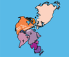
Tectonic Development of the Appalachian—Ouachita—Marathon Mountain Range (2 of 3)
map of the world showing location of continents 250 million years ago
250 Million Years Ago—Iapetus Ocean Closes. Pangea forms as the continents collide. The Appalachians are part of a larger zone of continental collision that includes the Marathon and Ouachita mountains in the southern United States, the Atlas Mountains in Africa, and the Caledonide Mountains in Greenland, the British Isles, and Scandinavia.
Permission must be secured from the individual copyright owners to reproduce any copyrighted materials contained within this website. Digital assets without any copyright restrictions are public domain.
Modified from “Parks and Plates: The Geology of our National Parks, Monuments and Seashores,” by Robert J. Lillie, New York, W. W. Norton and Company, 298 pp., 2005, www.amazon.com/dp/0134905172.
Public domain:Full Granting Rights
Image
Geologic Resources Division, Code: GRD
11/22/2019
11/22/2019
Public Can View
Monday, February 3, 2020 10:17:12 AM
Monday, February 3, 2020 10:17:12 AM
iapetus closes@10x.jpg
Friday, November 22, 2019 5:32:28 PM
jpg
422.6 kB
Scenic