Select Item below to DOWNLOAD - Once item is selected, right click and choose 'save as'
8058078350804d10b953a4d063350a40
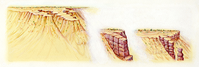
Three-part erosion sequence showing water run-off and freeze/thaw action on the steep slopes of the Amphitheater area creating fins of harder rock which later erodes along vertical cracks to form free-standing vertical columns known as hoodoos.
Three-part erosion sequence showing water run-off and freeze/thaw action on the steep slopes of the Amphitheater area creating fins of harder rock which later erodes along vertical cracks to form free-standing vertical columns known as hoodoos.
Abbr=PUB
U.S. National Park Service
Project=Folder; Art_Registration_No=PUB-0080 ; Reflective Art
Government owns art and all reproduction rights.
Public domain
Image
Bryce Canyon National Park, Code: BRCA
Bryce Canyon National Park, Utah
Latitude: 37.6052093505859, Longitude: -112.178703308105
Latitude: 37.6052093505859, Longitude: -112.178703308105
Image Management System : IMS 10760
20190904
01/01/1993 - 12/30/1993
Image_Size=14" x 7-3/4"; Count:9/9; Bryce Canyon National Park brochure
R2
Public Can View
Organization: Harpers Ferry Center
Address: Harpers Ferry Center, 67 Mather Place, Harpers Ferry, WV, 25425, 304-535-5050
Address: Harpers Ferry Center, 67 Mather Place, Harpers Ferry, WV, 25425, 304-535-5050
Monday, October 7, 2019 2:32:14 PM
Monday, October 7, 2019 2:32:14 PM
10760.jpg
jpg
150.5 kB
Museum