Select Item below to DOWNLOAD - Once item is selected, right click and choose 'save as'
7e1f0a9daded4954a16dfc280d3147e7
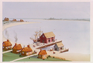
Aerial view of Salem Wharf in the early 1700's as seen from behind buildings.
Aerial view of Salem Wharf in the early 1700's as seen from behind buildings.
Abbr=AVA
U.S. National Park Service
Reflective Art
Government owns art and all reproduction rights.
Public domain
Acrylic on illustration board, (HFC ArtMedium)
Image
Salem Maritime National Historical Park, Code: SAMA
Salem Maritime National Historical Park, Essex County, Massachusetts
Latitude: 42.5195999145508, Longitude: -70.8868026733398
Latitude: 42.5195999145508, Longitude: -70.8868026733398
Image Management System : IMS 01952
20190904
01/01/1982 - 12/30/1982
Image_Size=W: 15" x H: 11"; Metric_Size=W: 38.07CM X H: 27.92CM; AVA Project #1; Slide Show #334, Plate 5
D5
Public Can View
Organization: Harpers Ferry Center
Address: Harpers Ferry Center, 67 Mather Place, Harpers Ferry, WV, 25425, 304-535-5050
Address: Harpers Ferry Center, 67 Mather Place, Harpers Ferry, WV, 25425, 304-535-5050
Thursday, October 3, 2019 6:05:30 PM
Thursday, October 3, 2019 6:05:30 PM
01952.JPG
jpg
69.7 kB
Museum