Select Item below to DOWNLOAD - Once item is selected, right click and choose 'save as'
7d59296d-8134-48d3-b791-8f2622664c02
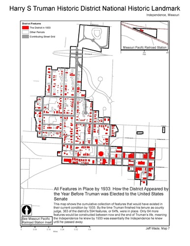
Map 7 Features in Place by 1933
Map of the resources in place by the year before Harry Truman ran for election to the United States Senate in 1933.
Map of the resources in place by the year before Harry Truman ran for election to the United States Senate in 1933.
Permission must be secured from the individual copyright owners to reproduce any copyrighted materials contained within this website. Digital assets without any copyright restrictions are public domain.
NPS/Jeff Wade
Public domain:Full Granting Rights
Image
Harry S. Truman National Historic Site, Code: HSTR
Harry S. Truman National Historic Site, Jackson County, Missouri
Latitude: 38.9012985229492, Longitude: -94.5307006835938
Latitude: 38.9012985229492, Longitude: -94.5307006835938
05/01/2011
01/01/0001
Public Can View
Thursday, September 9, 2021 8:50:26 AM
Thursday, September 9, 2021 9:23:23 AM
_0000 Map 7 Features in Place by 1933.tif
Monday, January 1, 0001 12:00:00 AM
tif
553.4 kB
Scenic