Select Item below to DOWNLOAD - Once item is selected, right click and choose 'save as'
7c5a492b-d0ed-4786-84a4-2d8221604390
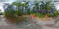
Bloody Angle / Elm Brook Hill, part 2
A modern roadway wooded on both sides. Enhancements of text and arrows indicate troop movements.
This image shows what happened after the Woburn militia opened fire on the British column and their flanking movements to the northeast.
Permission must be secured from the individual copyright owners to reproduce any copyrighted materials contained within this website. Digital assets without any copyright restrictions are public domain.
NPS Photo
Public domain:Full Granting Rights
Image
Minute Man National Historical Park, Code: MIMA
Latitude: 42.4526861111111, Longitude: -71.3017277777778, Elevation: 62.59
Minute Man National Historical Park, Middlesex County, Massachusetts
Latitude: 42.4533996582031, Longitude: -71.2959976196289
Minute Man National Historical Park, Middlesex County, Massachusetts
Latitude: 42.4533996582031, Longitude: -71.2959976196289
09/11/2020
09/11/2020
Public Can View
Thursday, September 17, 2020 3:29:55 PM
Thursday, September 17, 2020 3:29:55 PM
Bloody Angle position 2.jpg
RICOH RICOH, RICOH THETA V
1/2000 sec at f / 2
1.3 mm
ISO 320
Friday, September 11, 2020 8:32:49 PM
jpg
4.6 MB
Scenic