Select Item below to DOWNLOAD - Once item is selected, right click and choose 'save as'
785fba0e-32c7-415d-b53c-8fec3cd67911
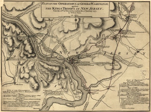
Plan of the operations of General Washington
Scan of historical map of New Jersey operations during the Revolutionary War
Plan of the operations of General Washington, against the Kings troops in New Jersey, from the 26th, of December, 1776, to the 3d. January 1777.
This image is used for the Primus Hall (Patriot of Color) story map.
Library of Congress declares this public domain because the date of publication is prior to 1922. For more information, see this url: https://www.loc.gov/resource/g3811s.ar127000/
Library of Congress, Geography and Map Division
Public domain
Image
Boston National Historical Park, Code: BOST
Boston National Historical Park, Suffolk County, Massachusetts
Latitude: 42.3734016418457, Longitude: -71.0557022094727
Latitude: 42.3734016418457, Longitude: -71.0557022094727
https://www.loc.gov/resource/g3811s.ar127000/
1777
01/01/0001
Organization: Library of Congress
Friday, April 29, 2022 8:39:39 PM
Friday, April 29, 2022 8:45:01 PM
New Jersey Operations.jpg
Monday, January 1, 0001 12:00:00 AM
jpg
293.3 kB
Historic