Select Item below to DOWNLOAD - Once item is selected, right click and choose 'save as'
75b68d72-c6bf-4221-a69f-ea35e719213a
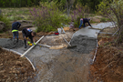
Roadwork on Devil’s Den
Center-frame is a fork in a partially paved footpath. In the upper-right path of the fork is freshly paved cement with a worker kneeling over to examine it. In the path to the right is a pair of workers measuring the dimensions of the path and smoothing out the freshly-laid cement. In the bottom-center of the frame is a section of the path that hasn’t had any cement laid yet. There are some construction implements in the crook on the side of the road.
Workers spread out cement over one of the footpaths of Devil’s Den
Permission must be secured from the individual copyright owners to reproduce any copyrighted materials contained within this website. Digital assets without any copyright restrictions are public domain.
NPS Photo
Public domain:Full Granting Rights
Image
Gettysburg National Military Park, Code: GETT
Gettysburg National Military Park, Adams County, Pennsylvania
Latitude: 39.804500579834, Longitude: -77.2384033203125
Latitude: 39.804500579834, Longitude: -77.2384033203125
05/05/2022 | Thursday, May 5, 2022
05/05/2022
Public Can View
Friday, May 13, 2022 3:22:03 PM
Friday, May 13, 2022 3:34:21 PM
Lawson_5-5-22_0009.jpg
Canon Canon, Canon EOS 60D 100, TAMRON 18-200mm F/3.5-6.3 DiII VC B018
1/80 sec at f / 9
18 mm
ISO 100
Thursday, May 5, 2022 9:23:24 AM
jpg
1.2 MB
Scenic