Select Item below to DOWNLOAD - Once item is selected, right click and choose 'save as'
74347bda-d13d-4e90-8696-e370648acb98
KNRI T-17 KNRI 00005960 gif
KNRI T-17 KNRI 00005960 gif
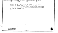
Survey monument record sheet, Sketch number: 00005960
U. S. National Park Service
This digital asset is in the public domain. When using this asset for any purpose, including online, credit: 'U.S. National Park Service, Land Resources Division'.
Public domain
Image
Knife River Indian Villages National Historic Site, Code: KNRI
Knife River Indian Villages National Historic Site, Mercer County, North Dakota
Latitude: 47.3684997558594, Longitude: -101.391998291016
Latitude: 47.3684997558594, Longitude: -101.391998291016
MONUMENTID for Monuments : KNRI T-17
2024/11/15
01/01/1967
NPS
Public Can View
Organization: Land Resources Division
Position: Program Coordinator
Address: 1849 C Street, NW, Suite 2340, Main Interior Building, Washington, DC 20240
Position: Program Coordinator
Address: 1849 C Street, NW, Suite 2340, Main Interior Building, Washington, DC 20240
Thursday, December 5, 2024 6:05:14 PM
Thursday, December 5, 2024 6:05:14 PM
KNRI_00005960.gif
gif
18.5 kB
Monitoring
,
Inventory
,
Map