Select Item below to DOWNLOAD - Once item is selected, right click and choose 'save as'
70cee52d-5fbf-4e26-809b-babdebb5b3c1
Hwy4PileBurn_2023.jpg
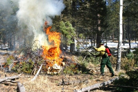
A wildland firefighter wearing protective gear adds a tree limb to a burning pile of brush.
Pile burns along the Highway 4 defensible space corridor
Pueblo Parks Fire Management Program
All Rights Reserved:Full Granting Rights:Pueblo Parks Fire Management Program
Image
Bandelier National Monument, Code: BAND
Bandelier National Monument, New Mexico
Latitude: 35.8187789916992, Longitude: -106.357299804688
Latitude: 35.8187789916992, Longitude: -106.357299804688
01/01/2003
01/01/0001
Public Can View
Organization: Pueblo and Four Winds Fire Ecology
Friday, May 23, 2025 6:07:05 PM
Friday, May 23, 2025 6:32:22 PM
Hwy4PileBurn_2023.jpg
Monday, January 1, 0001 12:00:00 AM
jpg
83.1 kB
Events