Select Item below to DOWNLOAD - Once item is selected, right click and choose 'save as'
70b64094-d723-499b-9209-effc603c4de0
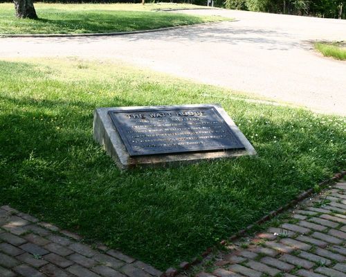
Freeman Marker #7, The Watt House at Richmond National Battlefield Park, May 2004
Images were contracted by the NPS Office of the Chief Information Officer as part of a larger project to add images of all Civil War monuments to the NPS Civil War Soldiers and Sailors System
South Overall View
U.S. National Park Service
Cast iron inscription tablet, 2'3"x3'5", mounted at a slant on a concrete slab which rests on a granite block base. Overall: 4' long, 3' wide, 1'6" high. || 1 of 61 markers erected by Battlefield Markers Association to locate key points of Civil War activity around Richmond. Could be considered beginning of movement to establish Park. Marks site of McClellan's right wing after Beaver Dam Creek.
Permission must be secured from the individual copyright owners to reproduce any copyrighted materials contained within this website. Digital assets without any copyright restrictions are public domain.
Public domain:Contract transferred all rights to the NPS
Image
Richmond National Battlefield Park, Code: RICH
Richmond National Battlefield Park, Hanover County, Virginia
Latitude: 37.57392, Longitude: 77.29072
Latitude: 37.57392, Longitude: 77.29072
01/24/2005
05/24/2004
Public Can View
Friday, August 20, 2010 1:27:03 AM
Wednesday, August 9, 2017 11:18:39 PM
RICH-LCS-81623_1.tif
Canon Canon, Canon EOS 10D
30 mm
ISO 100
Wednesday, May 12, 2004 9:10:20 AM
tif
14.2 MB
Inventory