Select Item below to DOWNLOAD - Once item is selected, right click and choose 'save as'
69db2379-f9e2-41a8-9268-e367c860ce6f
The Eads Bridge and the north pond
Looking down upon the Arch grounds with the north leg of the Arch at the right side of the image and the Eads Bridge at the top with the Mississippi River running through the photo
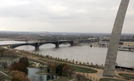
The Eads Bridge from the 19th floor of one Memorial Drive
Permission must be secured from the individual copyright owners to reproduce any copyrighted materials contained within this website. Digital assets without any copyright restrictions are public domain.
NPS Photo/Jennifer Clark
Public domain:Full Granting Rights
Image
Gateway Arch National Park, Code: JEFF
Gateway Arch National Park
Latitude: 38.6234588623047, Longitude: -90.175407409668
Latitude: 38.6234588623047, Longitude: -90.175407409668
11/07/2017
12/15/2020
Public Can View
Tuesday, March 30, 2021 9:30:38 AM
Tuesday, March 30, 2021 9:30:38 AM
eads crop.jpg
Tuesday, December 15, 2020 4:28:50 PM
jpg
78.4 kB
Scenic