Select Item below to DOWNLOAD - Once item is selected, right click and choose 'save as'
69b714a92c8a4711a6b04c419295168e
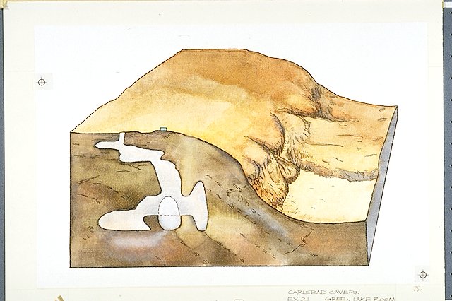
Block diagram showing the depths of the main sections of Carlsbad Caverns including the Green Lake Room relative to the surface features (i.e. Visitor Center, Natural Entrance, etc.).
Block diagram showing the depths of the main sections of Carlsbad Caverns including the Green Lake Room relative to the surface features (i.e. Visitor Center, Natural Entrance, etc.).
Illustration adapted from a sketch in "A Discussion and Field Guide to the Geology of Carlsbad Caverns", J. Michael Green, 1981, Figure 3.; Abbr=WE
U.S. National Park Service
Reflective Art
Government owns art and all reproduction rights.
Public domain
Geology, (HFC ArtTheme)
Image
Carlsbad Caverns National Park, Code: CAVE
Carlsbad Caverns National Park, Eddy County, New Mexico
Latitude: 32.1408996582031, Longitude: -104.553001403809
Latitude: 32.1408996582031, Longitude: -104.553001403809
Image Management System : IMS 05000
20190904
01/01/1985 - 12/30/1985
Image_Size=15" x 10"; Exhibit 21/Graphic # 21-6
I 15
Public Can View
Organization: Harpers Ferry Center
Address: Harpers Ferry Center, 67 Mather Place, Harpers Ferry, WV, 25425, 304-535-5050
Address: Harpers Ferry Center, 67 Mather Place, Harpers Ferry, WV, 25425, 304-535-5050
Monday, October 7, 2019 2:53:35 PM
Monday, October 7, 2019 2:53:35 PM
05000.JPG
jpg
58.5 kB
Museum